The Amazon Sea and Me
[Oneland - Take 3]
prepared by Don R. Hender
prepared by Don R. Hender
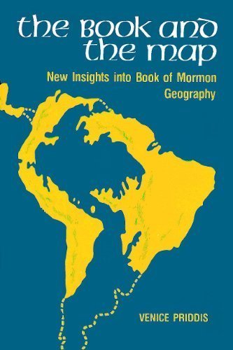
 Sister Venice Martin Priddis (1924-2009) is the author of the book entitled
'The Book and the Map:' New Insights into Book of Mormon Geography.
Sister Venice Martin Priddis (1924-2009) is the author of the book entitled
'The Book and the Map:' New Insights into Book of Mormon Geography.
 Though
not in agreement with a number of Sister Priddis' conclusions, I have found
the text to have been of great value as she explores a number of new concepts
not generally explored or covered by other authors following their own
subjectively considered opinions as to the possible geography to the Book of
Mormon. In particular, the concept that the scientifically supported Ancient
Amazon Sea was still existent during the Book of Mormon times and was part if
not all of that very east sea presented by the Book of Mormon text.
Though
not in agreement with a number of Sister Priddis' conclusions, I have found
the text to have been of great value as she explores a number of new concepts
not generally explored or covered by other authors following their own
subjectively considered opinions as to the possible geography to the Book of
Mormon. In particular, the concept that the scientifically supported Ancient
Amazon Sea was still existent during the Book of Mormon times and was part if
not all of that very east sea presented by the Book of Mormon text.
As covered in some detail on another web page entitled "When the Land Was One - Take 2", from the times when the land was one land and then separated in the days of Peleg according to the Biblical scriptures, over the course of South America's further formation, there was some existent period of time over which there was a great 'inland sea' where now there is but the great and mighty Amazon basin and Amazon river. Of course science will tell you according to their 'theories' that the time when the land was one and subsequently divided occurred ions of time ago, which is basically in direct conflict with the Biblical account of when those events happened. So often the learned scholar is faced to chose between the Biblical account and the theories of the ivory tower held by science.
One such 'science learned figure', though a good Mormon, is such as John
L. Sorenson, who has obtained great stature in the Book of Mormon georaphy
arena, particularlly in the eyes of and support of other University trained
scholars and scientists. John seems to consider himself the leading authority
on Book of Mormon geography and has written his own little book entitled
"Mormon's Map", in which he presents that he considers he has
entered into the mind of Mormon to objectively determine just what the Book
of Mormon geography must comply with in order to be acceptible by the 'modern
Book of Mormon scholar'. And to that end, John and his fellow followers have
taken it upon themselves to critique, and just about as often, discredit
all other proposed geographies and such concepts which do not meet John's
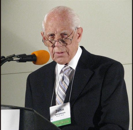 limited model criteria. And this John has done in relationship to Sister
Venice Priddis' text by almost beginning and ending upon the one matter as
to there ever having been an Amazon Sea over the course of Book of Mormon
time frame. Thus John has stated:
limited model criteria. And this John has done in relationship to Sister
Venice Priddis' text by almost beginning and ending upon the one matter as
to there ever having been an Amazon Sea over the course of Book of Mormon
time frame. Thus John has stated:
"The Book and the Map. New Insights into Book of Mormon Geography, by Venice Priddis (Salt Lake City: Bookcraft, 1975, $3.95, pp.), differs in focus from the volumnes discussed above, but the quality of scholarship is similiar. Ignoring all past serious study on Book of Mormon geography, Priddis picks one "key" statement and builds a fanciful picture of the Book of Mormon lands to accord with it alone--a picture, incidentally, that requires the Amazon and the Plate River basins to lie entirely under water. The evidence adduced is trivial, and the arguments are fatally flawed at point after point. Anyone willing to be this selective in what is to be noted and what ignored could construct at least two dozen other geographical correlations for the Nephite scriptures which could be equally (im)plausible." INSTANT EXPERTISE ON BOOK OF MORMON ARCHAEOLOGY, A review article by John L. Sorenson, professor of anthropology and sociology at Brigham Young University, Book Reviews, BYU Studies, Vol. 16, No. 3, (Spring, 1976), pp.429-432
John seems to me to be just as inconsistent in his comments as every other such author on the Book of Mormon geography who he critiques in his article. Personally I have found John Sorenson's scholarship credible enough to use his criteria to review such Book of Mormon geography matters as he has put a deal of effort into it. Yet I do not find John the perfectionist and authority on the matter that he and his followers portay him to be. John can be just as selective and subjective and ignoring of matters as he has acccused many of the others of being. To a great degree John has force fitted his own interpretations of 'Mormon's Mind' to comply with his own preselected 'limited geography site' of the Book of Mormon events. And his own focus on such matter is to fit the whole of all the significant activities of the Book of Mormon into a land whose size is comparable to the state of Utah.
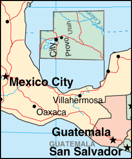
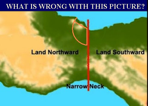 Let's look at the Sorenson Model with as much curtness as John has allowed in
his consideration of Sister Priddis' efforts. Despite the claimed total
objectivity in the effort, the design of his model is subjectively made to
bring a fit of the Book of Mormon geography to the region about the Tehuantepec
'narrow neck' of the Mesoamerican region. When placed in it proper orientation
the immediately applicable land area is as portrayed in the graphic. So
what is wrong with that picture?
Let's look at the Sorenson Model with as much curtness as John has allowed in
his consideration of Sister Priddis' efforts. Despite the claimed total
objectivity in the effort, the design of his model is subjectively made to
bring a fit of the Book of Mormon geography to the region about the Tehuantepec
'narrow neck' of the Mesoamerican region. When placed in it proper orientation
the immediately applicable land area is as portrayed in the graphic. So
what is wrong with that picture?
- 1. The Land 'Northward' is 'Westward' and the Land 'Southward' is 'Eastward'. While in the Jerusalem area Nephi wrote and it was translated in a manner that East was East, but the Sorenson effort to make it seem okay that the cardinal points of the compass are completely turned askew a full 90 degrees amounts to making north as being west, east as being north, south as being east and west as being south.
- 2. Thus it ought to be further pointed out that the Book of Mormon stated crossing of the narrow neck in a day and a half was from the east to the west sea, but actually on the Sorenson map that means traveling from north to south and the sea east is actually the north and the sea west is actually south, which all IS NOT in accord with the plain language and translation of the Book of Mormon upon the matter.
- 3. So to cross the supposed 'narrow neck' in a day and a half, which the Book of Mormon states is from east to west, on the red line one must travel the distance of 140 miles across the Isthmus of Tehuantepec's 'narrow neck' from north to south. And there is no advantage to traveling by anyother means than by land as there is across the Darien Isthmus from actual east to west where there is a westward flowing river that may be floated down for the majority of the 75 or so miles there. By the way, Willaim Dampier, explorer and buccaneer stated in his book that a 'Moskito' Indian could so travel across the Isthmus of Darien in a day and a half.
- 4. Another point of forced location and distance is the fact that the Mesoamerican Sorenson model places its hill of Cumorah but a fraction of the distance from the 'narrow neck' than that narrow neck is wide. Thus after some 10 years of fleeing before their enemy as fast as they could or else being killed and perishing by the hand of the pursuing Lamanite army over that 10 year period of time, the Sorenson model illogically would present a hill of Cumorah, the site of the final last great battle, less than a day's distance away from the narrow neck of land. That is a 3650 to 1 day ratio of logical discripency to account for according to the Sorenson model.
- 5. In addition, though the list could continue on and on, all the defensive cities which Captain Moroni built up all along the 'east coast' and east wilderness as named in the Book of Mormon, from Moroni to Mulek and Bountiful, are according to the Sorenson model all located not on the eastern coast line but all along the 'north shore'.
 Another interesting point is that the Sorenson limited land model theory
places all the recorded goings on in the Book of Mormon over a 1000 years for
the Nephites and over some 1.5 to 2 thousand years for the Jaredites, into a
land space comparable to the state of Utah.
Another interesting point is that the Sorenson limited land model theory
places all the recorded goings on in the Book of Mormon over a 1000 years for
the Nephites and over some 1.5 to 2 thousand years for the Jaredites, into a
land space comparable to the state of Utah.
Now certainly both the Nephites and the Lamanites would have lived at some time upon the lands of Mesoamerica. For some 2 to 3 hundred years the Nephite and Lamanite nations flurished together in that time of peace after the coming of Jesus Christ to the Americas. In such a time of prosperity and growth as surely the Nephites and Lamanites had had, the United States of American did not only expanded across the entire width of North American but up into the Territory of Alaska as well. And we are left to believe and accept that the Nephites and Lamanites remained in that same comparable time with even greater prosperity to remain but in a single state's limited size as the state of Utah alone?
In but one winter season the Creek nation traveled their 'trail of tears' under less duress from the deep south to the plains of Indian territory, some 1,000 miles. And the Mormon Pioneers would travel every summer season to continue to arrive in the Salt Lake Valley from an even greater distances still. Lewis and Clark's expedition over some two and one half years traveled some 8,000 miles to the west coast of American and back. And they would float their canoes down river on the way back coveing over 75 miles a day at times. Just how could a prosperous expanding people be held within the boundries of such as the state of Utah, which are just shy of being 400 miles from its northern border to its southern border?
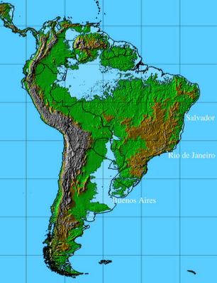 Well enough about all that. I suppose that the scientists in the ivory towers
of achademia as still a fuss about the Amazon Sea not being a feasible
possibility. Now one group of such scientists are today of just the opposite
mind in the opposite direction. If the feared global warning trends continue
many of them are predicting a return of the 'ancient' Amazon Sea in the
Amazon basin and beyond. Here is just one of their projected mappings which
doesn't even consider the already present day floodings of the
Well enough about all that. I suppose that the scientists in the ivory towers
of achademia as still a fuss about the Amazon Sea not being a feasible
possibility. Now one group of such scientists are today of just the opposite
mind in the opposite direction. If the feared global warning trends continue
many of them are predicting a return of the 'ancient' Amazon Sea in the
Amazon basin and beyond. Here is just one of their projected mappings which
doesn't even consider the already present day floodings of the
 'Pantanal Regions' or the
'Orinoco' floodings, which Orinoco river is already connect by a 'natural
canal' to the Amazon River system which allows one to boat up the Amazon from
the Atlantic and out into the Carribean via the Orinoco river.
'Pantanal Regions' or the
'Orinoco' floodings, which Orinoco river is already connect by a 'natural
canal' to the Amazon River system which allows one to boat up the Amazon from
the Atlantic and out into the Carribean via the Orinoco river.
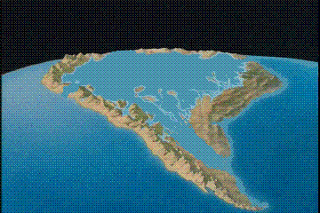
Now doesn't the map at the right look similar to Sister Priddis' map which John Sorenson totally considers impossible? Add in the flooding of the Pantanal and the already existent waterway and flooding of the Orinoco, which today presently cuts a water path through the upper northern regions of South America large enough for a boat to travel from the Atlantic to the Carribean via the 'inland route of up the Amazon and out the Orinoco' or up the Orinoco and out the Amazon. And this new Amazon Sea is possibly but 100 to 200 years away, not ions, depending upon global warming and not the great destructions as recorded in the Book of Mormon, of great up lifts which created great mountains and all the other distructive forces which may have accompanied a 'continental collision' occuring to close up and 'fill up' the Amazon Sea basin to the magnitude it is today.
Now as to Sorenson's pointed 'scientific' appraisal of the feasibility of an Amazon Sea as pictured upon the cover of Sister Priddis' little book, he ought to consider more the Biblical perspective and even other scientific analysis of just such an Amazon Sea's existence, which a number of such generated graphic images display and which this link to The Truth of Noah's Flood does reveal and contain as to how such may well fit into the Biblical time table. And even if such far aged graphics are as old as science says, both the Biblical dividing of the land in the days of Peleg and Noah's flood do give rise to the rebirth of an Amazon Sea for some duration of time after Noah's flood.
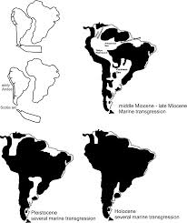
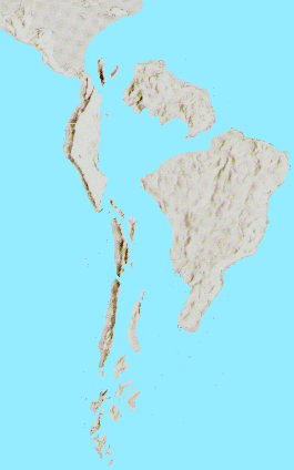
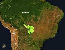
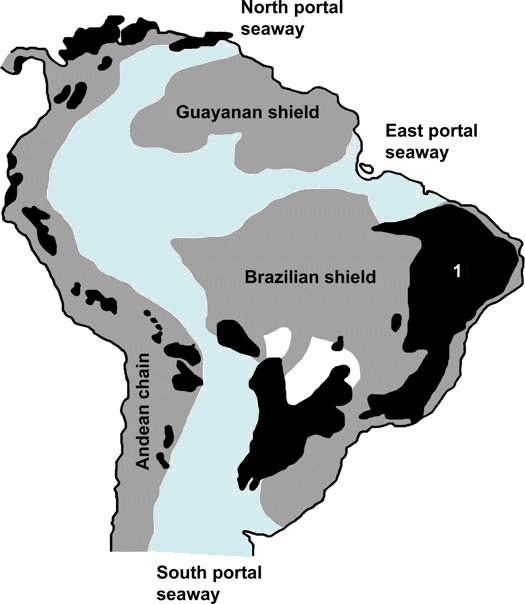
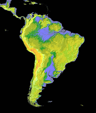
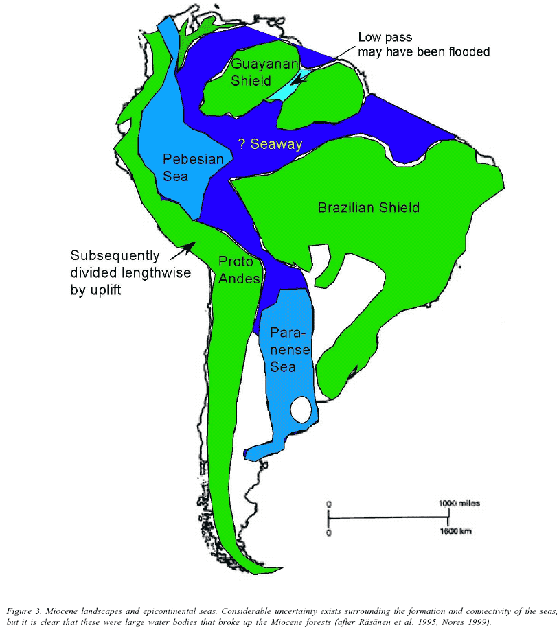 These images are from various internet sites which speak of the plant life
evidence as well as the time that the lands divided evidence of the great
'inland sea' of South America.
And even though these images are from differing sources, they all present
the once Amazon Sea much as Sister Priddis' book cover shows it to be. As
for where science and the religion of the Bible meet one who believes should
favor the Biblical account. And if they do not, the question as to why they
favor man's science over God's word ought to be considered.
These images are from various internet sites which speak of the plant life
evidence as well as the time that the lands divided evidence of the great
'inland sea' of South America.
And even though these images are from differing sources, they all present
the once Amazon Sea much as Sister Priddis' book cover shows it to be. As
for where science and the religion of the Bible meet one who believes should
favor the Biblical account. And if they do not, the question as to why they
favor man's science over God's word ought to be considered.
rev. October 29, 2013