A M A P | ||
|
|
|
|
MAP 1 |
The Americas have a narrow land area historically named 'Darien', which is Panama today with the most southern region still retaining the name of Darien. It is here that the map will begin to supported from the 'Teaching of the Prophet Joseph Smith' that states, "... Lehi went down by the Red Sea to the great Southern Ocean, and crossed over to this land, and landed a little south of the Isthmus of Darien, ..." (Joseph Smith, TPJS p. 267 & Times and Seasons). The Book of Mormon reports that Lehi's party was brought to the land south and that Mulek's party was brought to the land north, from whence Mulek's party further traveled into the land south, either by land or water to where they are found in the land of Zarahemla, north of the land of Nephi and the land of 'First Inheritance'. Lehi's route in red depicts that he journeyed by way of the Cauca River valley south and into Peru, ending up upon the western shore there as the land of first inheritance. Mulek's party in blue is shown to have sailed from the desolate land to the Magdalena River, which river could be navigated into the center of the land and the city of Zarahemla. Nephi's party separates and follows the Liahona's directions into the interior, east of the Land of first inheritance and still south of what would be the forested land of Zarahemla. |
|
|
For some 300 years the Lamanites of the land of first inheritance, the Nephites of the land of Nephi, and the Mulekites of the land of Zarahemla live separately; with the Lamanites and Nephites having relationships of wars. Then a series of four travel routes between the land of Zarahmela and the land of the 'Lehi-Nephi' occurs. 1) Mosiah in redish orange leads a Nephite remnant north to escape the Lamanites and they find the people of Zarahemla. They join together as one people under Mosiah. 2) A Nephite group of 'Zeniff' desires to return to the land of Nephi, their inheritance is marked in blue. The go down, back and down again before they settle in the land of 'Nephi' or 'Lehi/Nephi'. 3) Zeniff's people do not fare well and seek to find their way back to Zarahmela sending Limhi's explores marked by the green line. They take the wrong river valley north and travel all the way up into the land of desolation before they decide the people of Zarahemla must have been destroyed. 4) The combined people of Zarahemla, want to know the fate of Zeniff's party, so Ammon's explorers marked out by the brown line finds them. They have split into Lemhi's people and Alma's people who both find their way north to Zarahemla (routes not shown).
|
MAP 2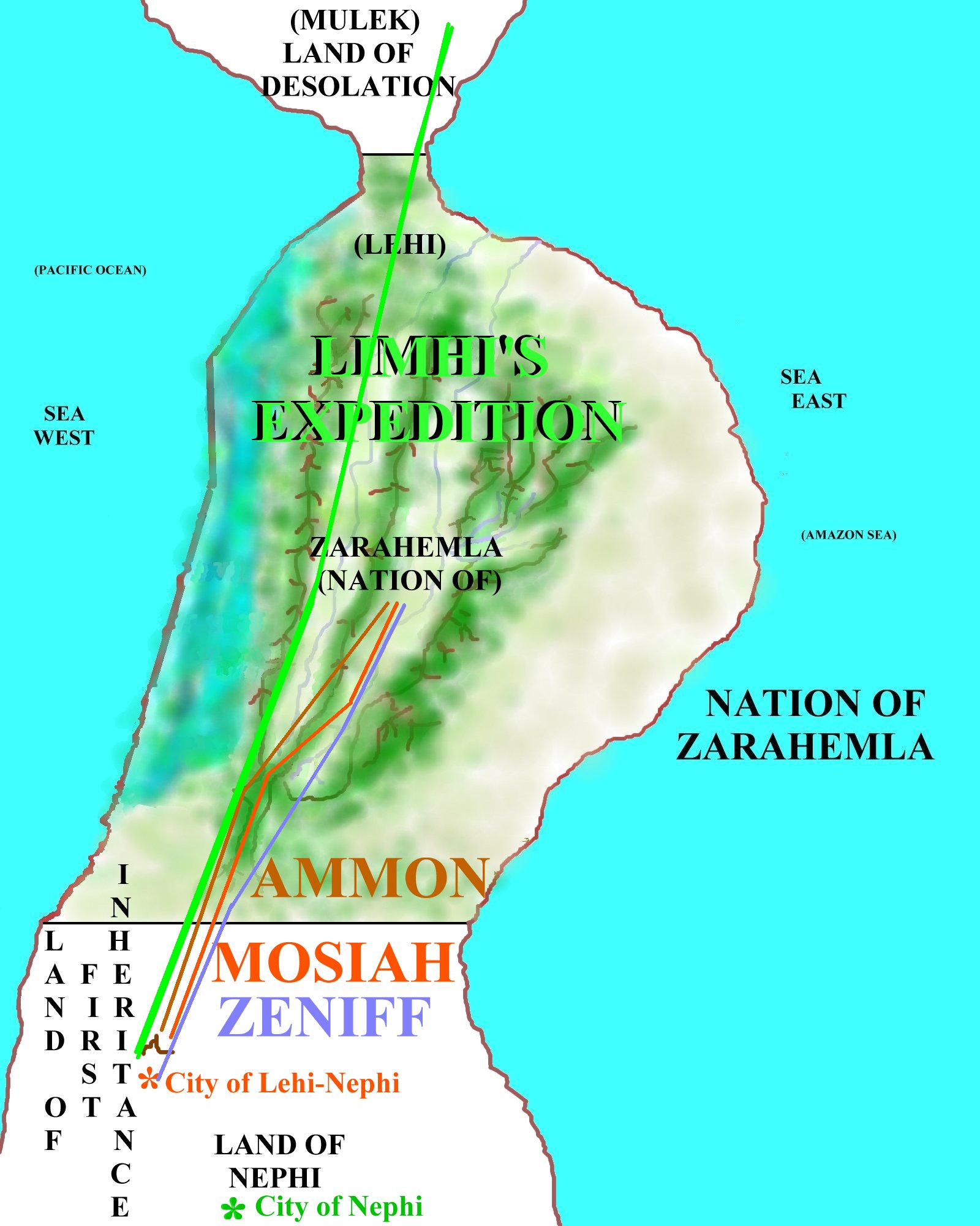 |
|
MAP 3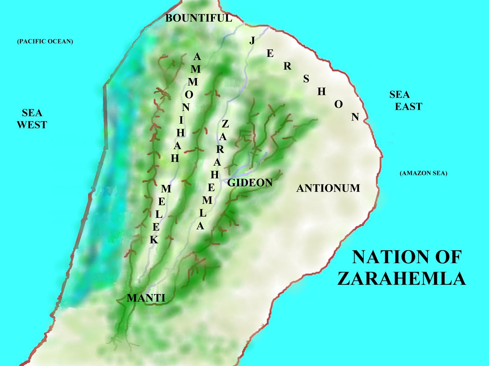 |
When the people of Zarahemla, and the Nephites of Mosiah, Lemhi and Alma all come together, they have spread out upon the land of Zarahemla in 7 or 8 land regions of Bountiful, Ammonihah, Melek, Manti, Antionum, Gideon, Jershon, an of course central Zarahemla though the whole of the land is the nation of Zarahemla. Bountiful is name for where Lehi's party first landed and first planted their first season's crops in the north of the land. Ammnonihah and Melek reside in the lower and upper Cauca or Sidom river valley. Zarahemla and Manti lay in the upper and central Sidon river valley. Gideon is in an east-west canyon valley that runs to the east coast. Along the plains of the east coast is Antionum in the south and Jershon along the northern shore coast. Each of these regions have their own Chief Judge and regional 'church' center. |
|
The Topology or Geography of the LandThe people of these regions have learned to use their water ways for travel. They can 'sail' up the Sidon (Magdalena River) all the way into the interior of the nation. And when traveling from the south to the north, they 'float their boat/canoe down the rivers from Manti down north to Zarahemla and out to sea. And from Melek on down north to Ammonihah and the various cities alligned with that region. Uniquely, the skilled traveler touts that he can cross the narrow neck from east to west in a day and a half, likely using the east to west flowing rivers to do so there. Even in the days of William Dampier and the Scottish Collony, the Indians could travel from sea east to sea west in a day and a half across the Darien. Now again, there is no official map of the Book of Mormon lands. The great land changes at the death of Christ likely changed the land along with starting to close up and fill in the Sea East. But as will be seen in the pages of the Book of Mormon, having such a map can provide logic and reasoning to the events of the wars of Captian Moroni and the Lamanites. The 'Gideon' short cut explains why Moroni and Lehi could out run the Zoramite/Lamanite army to the land of Manti to be set up and waiting to surprise attack them there. It also gives life to the flight of the sons of Helaman from before the Lamanites that persued them down the western wilderness valley and why the battle fields were so divided and manned the way they were with Moroni's armies in the north and east and Helaman's wariors with the other Nephite armies of the south and west. And it give life to such when it says that Alma traveled from the city of Zarahemla over and into the land of Melek, meaning over the mountain range and down into the upper valley where Melek was located. In short, it helps. Further Facts and ReasoningBoM Geo 101 | ||